-
Residential

RESIDENTIAL Service and Support
-
Business

BUSINESS Business Services
-
Learning Center

LEARNING CENTER Learning Center Resources
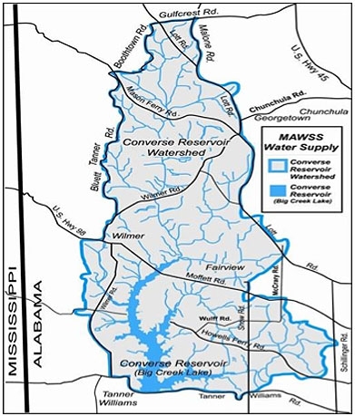 The J.B. Converse Reservoir Watershed lies within Mobile County and consists of 104 square miles of land that drains to the Reservoir. Seven major tributaries contribute to the Reservoir’s volume. Big Creek combined with Crooked Creek and Hamilton Creek are the three largest providing inflow into the Reservoir. Juniper Creek, Collins Creek, Long Branch and Boggy Branch are the other major feeder streams.
 MAWSS partners with the U.S. Geological Society to provide stream gauges that give real time data on the amount of water entering the Reservoir from the main tributaries. This helps MAWSS manage the water levels in the Reservoir. Gauges can be viewed at